One journey. Every kind of transport.
adsumRoute is a free multimodal journey planner for anywhere in the world. Scoot to the station, take the train to the airport, fly to the other side of the planet, then catch a ferry, all in one plan with local arrival times and an estimated cost for the whole trip.
Open the planner →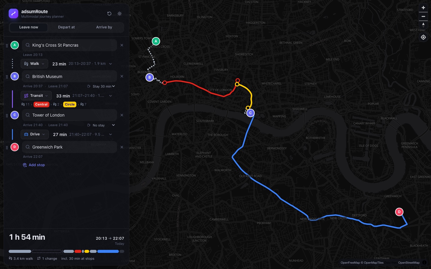
Why a multimodal route planner?
Most route planners give you one way to travel per search: driving directions, or public transport, or cycling. Real trips are messier. You might scoot to the station because the bus is slow, take the train into town, stop for lunch, then drive home with a friend. adsumRoute treats each part of the trip as its own leg with its own transport, and carries the timing from one leg to the next.
A different mode on every leg
Switch between walking, bus, rail, e-scooter hire, bike hire, cycling and driving at any stop. Change your mind and everything after it re-times instantly.
Stops that take time
Add as many stops as you like and say how long you'll stay at each. Connections after a stop are worked out from when you actually leave.
Depart at or arrive by
Leave now, leave later, or set a time to arrive and adsumRoute works backwards through every leg to tell you when to set off.
Public transport that lines up
Timetabled buses, trains, Tube and trams, with live delays where operators publish real-time data. Pick a later departure and the rest of the trip follows.
Live scooters and hire bikes
Finds the nearest available e-scooter or hire bike, adds the walk to it and, for docked schemes, the walk from the return dock.
Suggested routes
Enter a start and destination and tap Suggest routes: park & ride, cycling to the station, flying with different ways to the airport and more, ranked as fastest, cheapest and fewest changes.
Flights, worldwide
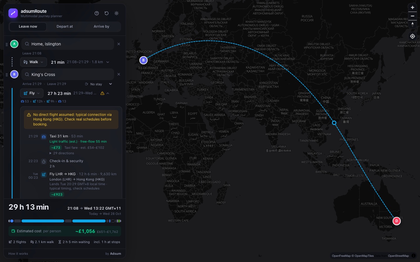
Nearest suitable airports, then your choice of how to get there: taxi, drive and park with the shuttle bus, dropped off, or real airport trains. Check-in, typical connections, landing times in local time, and fare estimates by cabin class.
Ferries and ships
Real ferry timetables where they're published; elsewhere the crossing follows global shipping lanes, from a short ferry hop to weeks at sea.
What the whole trip costs
A per-person estimate for every leg (taxis, fuel, scooters, flights and boats) adding up to one total, with ranges and links to check real prices.
Time-aware driving
Driving legs allow for typical rush-hour congestion, plus extra time for parking. Avoid tolls or motorways per leg.
How to plan a mixed-transport journey
- Set your start and destination. Search for a place, use your location, or click the map.
- Add stops. Insert stops anywhere along the route: a station, a café, a meeting. Drag to reorder.
- Choose the transport for each leg. Tap the mode between two stops: walk, bus, train, scooter, bike hire, bike or car.
- Pick your time. Leave now, depart at a set time, or arrive by a deadline.
- Fine-tune. Open any leg to choose a different departure, change walking pace, limit changes, go step-free, or add buffer time.
What makes it different
| Capability | Typical journey planner | adsumRoute |
|---|---|---|
| Different transport on each leg of one trip | One mode per search, or a fixed combination chosen for you | You choose every leg |
| Multiple stops with time spent at each | Often driving only | Any mode, with dwell times |
| E-scooter or hire bike, then train | Rarely joined up | Walk to vehicle, ride, then the next departure |
| Arrive-by across a multi-stop, multi-mode trip | Usually single leg | Works back through every leg |
| Plane, train and boat in one plan, door to door | Separate apps for each | One journey, local times throughout |
| Total cost of a mixed journey | Rarely shown | Per-person estimate for every leg |
| Account required | Often | Never |
Frequently asked questions
What is a multimodal journey planner?
A multimodal journey planner works out a single trip that uses more than one kind of transport, for example walking to an e-scooter, riding it to a station, taking a train and then driving. adsumRoute lets you choose the mode for every leg yourself and joins the timings together so you can see the real end-to-end arrival time.
Can I combine an e-scooter or hire bike with a train or bus?
Yes. Add a stop at the station, set the first leg to e-scooter hire or bike hire and the next leg to train, Tube or bus. adsumRoute finds the nearest available vehicle where the operator publishes open availability data, includes the walk to it, and lines the ride up with the next departure.
Can I plan a journey to another country, with flights?
Yes. Set a leg to Flight and adsumRoute picks the nearest suitable airports at each end. Choose how you reach the airport (taxi, drive and park with the car-park shuttle, dropped off, or public transport from real timetables) and how you leave it (taxi, public transport, car hire or a pick-up). Check-in, typical connections through major hubs and passport control are included, with landing times in local time. Routing and timings are a typical pattern rather than a live schedule, with a link to check real fares.
Can I travel by boat or ferry?
Yes. Boat legs use real ferry timetables where operators publish open data. Elsewhere adsumRoute plans the crossing along global shipping lanes, treating short crossings as ferries and long ones as cruise or freighter passage, with time at sea and an estimated fare.
How are journey costs worked out?
Each leg gets a per-person estimate: walking is free, driving is fuel, taxis, scooters and bike hire use typical tariffs, flights use a distance-based fare model by cabin class, and boats are priced per crossing or per day at sea. Every estimate shows a range and, where possible, a link to check the real price. Public transport fares are rough estimates because open timetable data rarely contains fares.
Does adsumRoute take traffic into account?
Driving legs use a time-of-day traffic estimate, so a rush-hour drive takes longer than the same drive late at night. It is an estimate based on typical congestion patterns, not live incident data, and the app labels it that way.
Does it show live train and bus times?
Public transport legs use published timetables and apply live delays and cancellations wherever the operator provides open real-time data. Each departure is marked Live or Scheduled so you know which you are looking at.
Can I plan a journey to arrive by a certain time?
Yes. Choose Arrive by and adsumRoute works backwards through every leg, including time spent at each stop, and tells you when to leave.
Is adsumRoute free, and do I need an account?
It is free and there is no account or sign-up. Your journey is saved only in your own browser.
Where does the routing data come from?
adsumRoute is built entirely on open data and open-source software: OpenStreetMap for maps and streets, Valhalla for walking, cycling, scooter and driving routes, MOTIS and Transitous for public transport timetables, and GBFS feeds for shared scooters and bikes, OurAirports for the world's airports, and Eurostat's SeaRoute network for shipping lanes.